


GEO Solutions
Non-collective Sanitation
Published on 10 February 2016
NON-COLLECTIVE SANITATION UNDER GEO SUPERVISION.
Map, analyze and edit your non-collective sanitation facilities. GEO Non-Collective Sanitation enables you to oversee and supervise all your non-collective sanitation facilities.
Manage your ...

GEO Solutions
Urban Planning
Published on 10 February 2016
URBAN PLANNING FROM THE GIS ANGLE.
Locate, edit and analyze your urban planning records directly within their geographical context. GEOXALIS integrates the spatial dimension at the heart of your urban planning and land management processes.
GEOXALIS ...

GEO Solutions
Land Zoning
Published on 10 February 2016
LAND ZONING CROSSED WITH YOUR CADASTRAL DATA.
Combine GEO Land Zoning together with GEO Cadaster to access, disseminate and process your data related to land zoning: districts maps, urban planning data and all kinds of land zones.
Enrich your ...

GEO Solutions
GEO Solutions
Published on 10 February 2016
MODULARITY AND ACCURACY
Business Geografic provides a wide and modular range of GEO solutions for all kinds of public and private structures. All GEO solutions are interconnected within the GEO platform to ensure perfect technological consistency.
Your ...
GEO Decisions
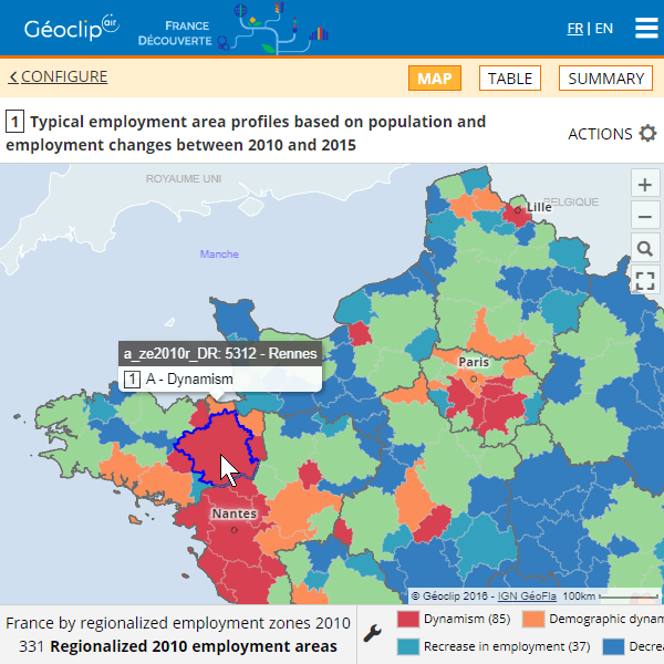
Géoclip
Published on 17 September 2019
Draw the portrait of your territory through a geostatistical observatory in web mode. Observatories based on Géoclip are benchmarked for their semiological relevance and quality of reporting.
Géoclip is a statistical web mapping solution for all geostatistical ...
GEO Decisions
équitée
Published on 10 February 2016
Set and launch automated territorial diagnoses. Equitée is a geo-analytics tool aimed at drawing territorial strategies by aggregating, filtering and synthesizing very big volumes of data and indicators.
Model, test and manage your land programs. Equitée ...
GEO Technologies
GEO TECHNOLOGIES :
interoperability and power.
GEO Solutions
GEO SOLUTIONS :
modularity and accuracy.
GEO Decisions
GEO DECISIONS :
spatial intelligence for all.
Page 5 of 6


